
In today’s era of spatial data and remote sensing, mapping the Earth’s surface has gone far beyond traditional paper maps. Technology allows us to create detailed 3D representations of terrain using digital elevation data. Three models commonly used in digital topography are DEM (Digital Elevation Model), DSM (Digital Surface Model), and DTM (Digital Terrain Model).
What Is a Digital Elevation Model (DEM)?
A DEM is a digital representation of the Earth’s surface that stores elevation values in a gridded format. Each cell in the grid represents a specific geographic location and its corresponding height above sea level. DEMs can be created using data collected from satellites, drones, radar, or LiDAR systems.
What Is a Digital Surface Model (DSM)?
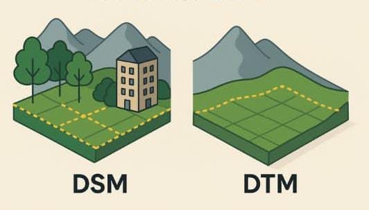
A DSM captures everything on the Earth’s surface, including vegetation, buildings, and other man-made structures. DSMs are especially valuable in environments where the presence of vertical structures matters, such as in urban planning and city modeling.
What Is a Digital Terrain Model (DTM)?
A DTM represents the bare-earth surface, with objects such as buildings and trees removed. DTMs are particularly useful in environmental and hydrological analyses, such as modeling surface water flow and flood risk.
Key Differences Between DSM, DTM, and DEM
- DSM: Represents the elevation of the Earth’s surface plus all objects on it.
- DTM: Represents the elevation of the bare ground, with all objects removed.
- DEM: A generic term that may refer to either DSM or DTM, depending on the context.
Why Choosing the Right Model Matters
The choice between DSM, DTM, and DEM depends on the specific goals of a project. For instance, a hydrologist modeling flood scenarios will require a DTM to understand how water moves over the land surface. On the other hand, an architect planning a new development in a dense city will benefit from a DSM to assess building heights and rooftop accessibility.
Applications Across Disciplines
Digital elevation models are widely used across various fields, including:
- Environmental science: Monitoring deforestation, landslides, and habitat loss
- Urban planning: Evaluating development impact, infrastructure planning
- Geology: Mapping fault lines, volcanic terrain, and slope stability
- Disaster management: Planning evacuation routes and assessing risk zones
- Civil engineering and public policy: Designing resilient infrastructure
Tools such as QGIS, ArcGIS, and Google Earth Engine enable professionals to process and analyze elevation models with powerful spatial analysis capabilities. These technologies are transforming how we interact with the landscape, make decisions, and plan for the future.